

About Us
At BAC our committment is clear: ensuring our culture, language, and knowledge live on for future generations. Through language reclamation and revitalisation, cultural education, and on Country programs, we continue the legacy of our Elders and strengthen pathways for our young people.


Bangerang Aboriginal Corporation
While the Bangerang Aboriginal Corporation (BAC) was officially registered in 1994, our role as the original custodians of this land spans thousands of years. Long before formal registration, our ancestors were doing the vital work of managing, protecting, and caring for our country.

“Land is the starting point from where everything in our world began. We don’t own the land, the land owns us. We see our bodies as the land and our veins are the rivers that flow through us, nourishing us and sustaining life. We are spiritually connected to the land, like an artery and its tributaries – like the life-giving water that flows through the Ovens River and its tributaries, from the mountains, down across the plains and into the mighty Murray River”
– Uncle John ‘Sandy’ Atkinson AM.
Originally established in 1994 as the Bangerang Goulburn Murray Tribe Aboriginal Corporation, BAC was reformed in 2014 by our founding Elders to better advocate for the rights and interests of our people. Today, BAC serves as the representative body for the clans and families of the Bangerang Nation—the People of the Tall Trees. The Bangerang Nation consists of the Moirathban, Toolinyagan, Wolithiga, Kailthban, Ngarrimowro, Angootheraban and the Pikkolatpan tribes.
Our clans and families are the Traditional Owners of a large tract of Victoria's Goulburn Murray and Ovens Murray Regions, as well as the Southern Riverina Murray Region of New South Wales. We are indelibly tied to our country as our creator, Baimiya, defined—from the rivers and wetlands to the trees that line their banks, the valleys and plains, and the western edges of the high country alongside the animals Baimiya created.
Our Mission
Our work today is rooted in preserving our traditional laws, beliefs, customs, sovereignty, language, and culture. By caring for our land, water, and sky country, we lay the groundwork for recognition, reconciliation, and self-determination—empowering our community through sustainable social and economic development.
Always was. Always will be Bangerang Woka (Country).
Bangerang Woka | Bangerang Land
Many maps have been created over the years, depicting Bangerang country and the original inhabitants of Victoria.
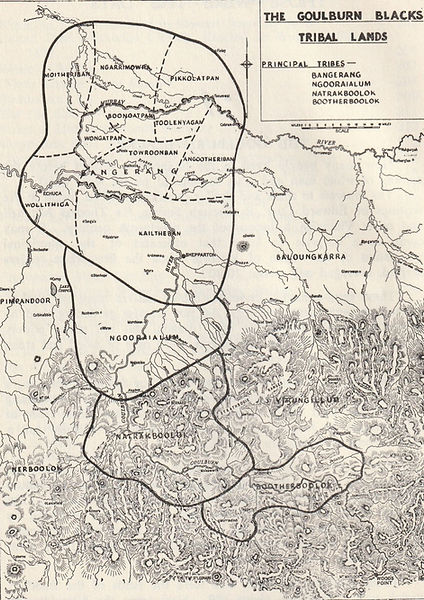
1886 Edward Curr Map
One of the earliest versions of these maps was created in 1886 by Edward M Curr, an Australian pastoralist who spent years managing sheep stations across Victoria during the 1840s, particularly around the Goulburn River and Murray River regions. Curr spent many years documenting his extensive interactions with the Traditional Owners of these areas. He produced two major written works featuring information on the people and culture of the Bangerang nation: Recollections of Squatting in Victoria (1883) and The Australian Race: It's Origin's, Languages, and Customs (1886).

1940 Dr Norman Tindale Map
The Tindale Map, created by anthropologist Dr. Norman Tindale, meticulously details the language and tribal boundaries of Aboriginal Australia. First published in 1940 and revised in 1974, it identifies over 250 distinct language groups and 600 dialects as they existed prior to European settlement. The map was compiled through decades of extensive field research and interviews with Aboriginal Elders across Australia, led by Tindale and Joseph Birdsell between 1935 and 1966. In this map, the Bangerang name can be seen in an alternate spelling Pangeran(g).

2016 VACL Map
Before colonisation, approximately 40 distinct Aboriginal languages were spoken across Victoria, alongside numerous dialects.
The primary goal of the VACL map is to:
-
Retrieve, revive, and strengthen Victorian Aboriginal languages by raising public awareness.
-
Serve as an educational baseline to help communities re-establish connections with their ancestral heritage and identity.
-
Provide a visual representation of the complex linguistic boundaries that defined the state long before modern map lines were drawn.